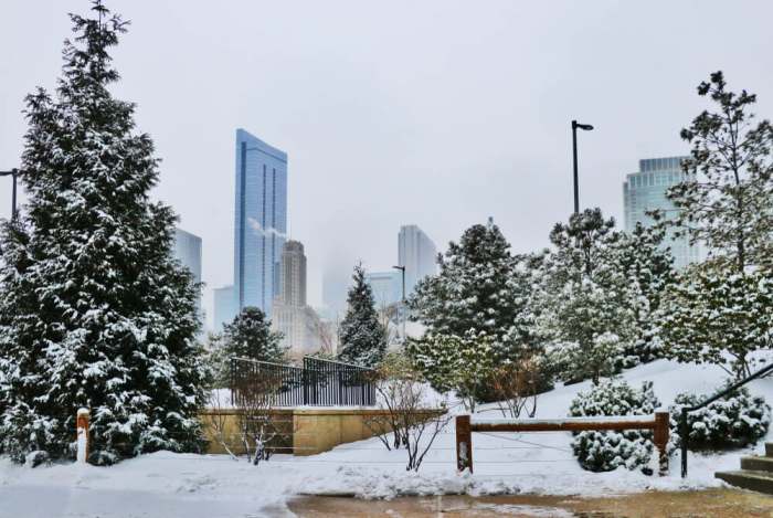
Record-Breaking Accumulation Rivals the Legendary 1978-79 Season
Chicago has already received 17.1 inches of snow by December 7, 2025—nearly matching last winter’s entire seasonal total in just nine days of active snowfall. This represents the fastest accumulation since the legendary 1978-79 winter, when 24.1 inches had fallen by the same date. The National Weather Service rates this winter’s severity as “extreme” on the Accumulated Winter Season Severity Index, and forecasters say the snowy pattern shows no signs of stopping.
A Record-Breaking November Day Set the Stage
The 2025-26 winter announced itself emphatically on November 29, when 8.4 inches buried O’Hare Airport—the single snowiest November day in 141 years of Chicago weather records. The previous record, 8.0 inches set on November 6, 1951, fell as a post-Thanksgiving winter storm brought blizzard conditions to the region. Midway Airport recorded 7.2 inches, while the NWS office in Romeoville measured 8.9 inches.
This was only the sixth time since 1884 that Chicago received 10+ inches of snow in November, and the largest single storm total since January 2021’s 10.8-inch event. The storm triggered Chicago’s first Winter Weather Warning in November since 2018. A chunk of the polar vortex brought record cold -40°F air overhead, according to meteorologists, supercharging the lake-effect snow machine as frigid air moved down Lake Michigan.
The December 6-7 Alberta Clipper Compounded the Totals
Just one week later, a fast-moving Alberta Clipper system swept through from Saturday night into Sunday morning, December 6-7, delivering 3 to 7 inches across the metro area. The storm’s heaviest snow fell in the northern suburbs, with Sleepy Hollow in Kane County recording 7.1 inches, while Lindenhurst, Capron, and Oregon each saw 7.0 inches. Streamwood received 6.5 inches, and Glenview and Evanston measured 6.0-6.2 inches.
O’Hare recorded 4.8 inches while Midway saw 4.3 inches. The southern suburbs received notably less—Tinley Park got just 2.0 inches and Joliet only 2.2 inches—creating a sharp gradient along the I-80 corridor.
An Alberta Clipper is a low-pressure system that forms near the Canadian Rockies in Alberta, then races east-southeastward at speeds of 40-50 mph. The term was coined in the late 1960s by Milwaukee NWS meteorologist Rheinhart Harms, who named them after the speedy clipper ships of the 19th century. While these systems typically produce only 1-3 inches, this clipper tapped additional Great Lakes moisture and dropped snow at rates up to one inch per hour.
How This Compares to 1978-79’s Historic 89.7-Inch Season
The current pace places 2025-26 as the fourth-snowiest start on record through December 7, trailing only 1978 (24.1 inches), 1950 (18.3 inches), and 1940 (17.6 inches). The 1978-79 winter remains Chicago’s all-time snowfall champion at 89.7 inches—a mark set during what locals called the “brutal trilogy” of brutal late-1970s winters.
That season’s defining moment came January 12-14, 1979, when a blizzard dumped 20.3 inches over 38 hours. Snow depth peaked at 29 inches, O’Hare closed for 96 hours, and temperatures plunged to -19°F. The snow didn’t fully melt until March 6—51 days later. The city’s botched response cost Mayor Michael Bilandic his job; he lost the February primary to Jane Byrne, who became Chicago’s first female mayor.
The comparison to today’s winter is striking in its early-season intensity. By December 7, 1978, Chicago had 24.1 inches—about 7 inches more than 2025’s current total. However, this year’s nine-day stretch from November 29 to December 7 produced 15.4 inches, the snowiest nine-day period since February 2021.
Last Winter’s Paltry Totals Make This Year Feel Even More Extreme
The 2024-25 winter delivered just 17.6 inches total—the tenth-least snowy winter on record. Meteorological winter (December through February) saw only 11.9 inches, running 17.7 inches below normal. That context makes 2025-26’s early accumulation particularly jarring: Chicago has already matched nearly an entire season’s worth in barely a week of active snowfall.
Forecasts Suggest the Pattern Will Continue
Another shot of Arctic air arrives December 12-14, with overnight wind chills potentially dropping below zero. La Niña conditions favor above-normal precipitation for the Great Lakes through winter. AccuWeather predicts a “stormy winter” for the Midwest with the biggest storms at season’s start and end. Climate Impact Company forecasts above-normal snowfall each month through February.
December has already seen 6.7 inches at O’Hare—nearly the monthly average of 7.6 inches—with three weeks remaining. NOAA’s official outlook shows equal chances for above or below average temperatures but leans toward wetter conditions overall. La Niña may transition to neutral by January-March, which could moderate the pattern.
Travel Chaos and Massive City Response
The human toll has been significant. The November 29 storm alone cancelled over 1,232 flights at O’Hare and 246 at Midway, with peak delays averaging five hours. O’Hare ranked as the nation’s most weather-impacted airport that weekend. The December 7 clipper added another 350 cancellations and prompted a ground stop until 9:15 a.m.
On the roads, DuSable Lake Shore Drive’s northbound lanes shut down after a five-car pileup near Oakwood Boulevard. A school bus struck a utility pole in McHenry. Illinois State Police responded to dozens of spinouts across the interstate system. Evening commutes stretched past an hour on major expressways.
City Services Mobilize at Scale
Chicago’s Department of Streets and Sanitation activated Phase II snow operations, deploying over 220 salt spreaders overnight and maintaining more than 300 snow vehicles across the fleet. The city sits on 425,000 tons of salt stockpiled at strategic locations to cover 9,400+ lane miles.
Lesser-known city measures include mixing beet juice into salt brine—the sugar lowers the freezing point and helps salt adhere to pavement—and deploying up to 200 garbage trucks fitted with “quick hitch” plows during major storms. Metra crews literally set fires on train tracks near Union Station to prevent switch mechanisms from freezing.
The winter overnight parking ban took effect December 1, running through April 1 with $150 towing fees plus tickets awaiting violators. Some 284 warming centers are open citywide, with six designated facilities activating whenever temperatures drop below 32°F.
Unique Perspectives From the Frozen Landscape
Chicago is piloting municipal sidewalk snow clearing in four neighborhoods—Austin, Belmont Cragin, Uptown, and parts of the South Side. If approved, Chicago would become the largest U.S. city to plow its sidewalks, at a cost of $1.1-3.5 million.
Meanwhile, hardy Chicagoans adapted in characteristic fashion. A photographer captured surfers riding waves at Montrose Beach in 17°F temperatures on December 4. Anna Bettmering, a traveler from Germany stranded at O’Hare, offered the understatement of the season: “I will come back when it’s not winter.”
Looking Ahead
Chicago’s 2025-26 winter has delivered more drama in its first two weeks than the entire previous season combined. The record-shattering November 29 snowfall, followed by persistent clipper systems, has pushed accumulation to levels not seen this early since before the Blizzard of ’79 reshaped Chicago politics.
With La Niña favoring continued precipitation and forecasters predicting an active pattern, this winter may yet challenge the legendary 1978-79 season—though reaching that 89.7-inch total would require sustained snowfall through March. For now, Chicago has been reminded what a real winter feels like, and the season is just getting started.